
Cornfield Mound Group &
Chief NawKaw (Nąga)Village

“In the midst of a group of seven effigies, now effaced, the Winnebagoes of early times had a council house. The location is near the junction of Mound and Water Streets, near the rapids of the Baraboo River. Mr. Canfield states that when he arrived in Baraboo in 1842, a pole flying a flag made of skins was still standing to mark the site of the council house, which was located there by Cal-i-mi-ne, the head chief of the Winnebagoes.”
Harry E. Cole – 1918
A Standard History of Sauk County, Wisconsin, p. 149-150
"Some time in October 1839, five of us. Berry Haney, Burk Fairchild, Solomon Shore, Samuel Taylor and myself crossed the bluffs over to the Baraboo Valley. The trail led us over the bluffs immediately back of what is now known as the Teals' place, the highest peak, I think, in the centre range between the prairie and Baraboo. The trail led us directly to the Baraboo river, at the place where Maxwell's mill dam now stands. Here we forded the river and entered the Indian Chief, Caliminee’s, village, where we were very warmly and hospitably received. We rested and refreshed ourselves and horses, and were much amused in seeing the Indians playing at cards and horse racing. Some of them would stake their last string of Wampum on a single chance at cards. The game we could not understand. After spending about two hours at this village we started to traverse the river above, which we did, wherever it was approachable, as far up as Dandy’s village, which was five or six miles above.”
Charles O. Baxter - c. 1861
Outline Sketches of Sauk County, Volume 2, p. 57
A Standard History of Sauk County, Wisconsin – H. E. Cole – 1918
p. 149-150 Baraboo
1—Fair Ground Mounds: Just north of the Fair Grounds, in the southeast quarter of the northeast quarter of section 36, were two tumuli in front of the residence of Bradbury Robinson. In the process of improving his grounds, in 1895, they were leveled. Among the relics unearthed was a brass tomahawk pipe, subsequently described in the "Wisconsin Archaeologist."
2—Crandall Group: In the southeast quarter of the northwest quarter of section 36, on the property of Mrs. Katherine Crandall Train, was once a fine group of mounds. One of the. most interesting was a deer effigy, 135 feet long, the hind quarters of which were destroyed by the excavation for a building. The part of the figure representing the head and antlers lies in the yard to the east of the Train Residence, the single beam of the antler being easily traced although much of it is not more than three inches in height. A lizard effigy formerly could be traced with its head close to the antlers of the deer, but much of it (when perfect 330 feet in length), has been leveled, as well as various tumuli to the west of the house.
3—Cornfield Group: The eastern line between sections 36 and 1 crosses a rather abrupt sandstone ridge, on the crest of which are to be seen traces of a few tumuli. At the foot of the near north slope the later Winnebagoes cultivated corn. As is evident from one of Mr. Canfield's early plats, in this group were originally twelve tumuli and eight effigies. A few relics, including a crude iron axe, have been unearthed from these mounds.
4—Council House Group: In the midst of a group of seven effigies, now effaced, the Winnebagoes of early times had a council house. The location is near the junction of Mound and Water Streets, near the rapids of the Baraboo River. Mr. Canfield states that when he arrived in Baraboo in 1842, a pole flying a flag made of skins was still standing to mark the site of thecouncil house, which was located there by Cal-i-mi-ne, the head chief of the Winnebagoes.
5—Remington Mounds: These mounds lay on the crests and upper slopes of the irregular ridge that skirts the north side of the Baraboo River and upon which a portion of the City of Baraboo is built. Beginning at Hickory Park, close to Fifth Street, they formed an almost unbroken series extending across Second Street onto the property of Mrs. S. S. Remington. Near the residence the string of mounds branched, one short row extending eastward and the other following the crest of the ridge along both sides of Mound and First streets as far as Rosaline Street. Nearly all the mounds are leveled, but traces of them are still to be seen at the junction of Mound and Remington streets. When visited by Mr. Canfield and Dr. F. W. Putnam, of the Peabody Museum, as early as 1883, most of the effigies had been obliterated by city improvements.

“Nawkaw” - Naga, “Wood” or “Tree” "Caramaunee" — Keramąnįga, "Walking Turtle."
This name can be spelled many ways - Cari-maunee, Carrymaunee, Carimimie, Caramaunee, Calimine, Carramana, Kay-rah-mau-nee, Karimine, Karrymaunee, Kerry-man-nee, and Kariminee.
“He was a large, square-shouldered, stout man, not very tall, but with a powerful frame and long face... Caramaunee bore a most excellent character, was liked by all traders, and was friendly to the whites. "When I saw him last, about 1830, he seemed nearly a hundred years of age. He said he was out with Colonel Dickson in the War of 1812, went with the Menominee to Sandusky, and was at Mackinac when Major Holmes was shot by L'Espagnol."
~William Powell, William Powell’s Recollections, p. 151-152
Portrait and Description of Chief NawKaw
McKenny, Thomas & Hall, James & Todd, Hatherly & Todd, Joseph. “History of the Indian tribes of North America: with biographical sketches and anecdotes of the principal chiefs. Embellished with one hundred portraits from the Indian Gallery in the War Department at Washington.” Philadelphia: D. Rice & Co. 1872.
“The countenance of this chief is prepossessing, and indicative of his true character. He was a firm, sagacious man, of upright deportment, and pacific disposition, who filled his station with dignity, and commanded respect by his fidelity to his engagements. His name is less expressive than most of those which are borne by Indians of reputation the word Nawkaw signifying wood. He was of the “Winnebago tribe, and of the Caromanie or Walking Turtle family, winch is of the highest distinction. The name Caromanie, among the Winnebago, implies rank and dignity, conveys the idea of sovereignty, and is, therefore, highly respected;...
This chief was the head of his tribe, who inhabited a broad and beautiful country, lying between the Mississippi and Lake Michigan, and spread out in plains of great extent, fertility, and magnificence...
Nawkaw was a man of large stature and fine presence. He was six feet tall, and well made. His person was erect, his muscles finely developed, and his appearance such as indicated activity and great strength. Like many of his race, he was remarkably fond of dress; and even in the last days of his protracted life, devoted the most sedulous care to the decoration of his person. His portrait affords evidence of his taste; the head-dress, the ear-rings, and the painted face, show that the labors of the toilet had not been performed without a full share of the time and study due to a matter of so much importance; while the three medals, presented to him at different times, as the head of his tribe, and as tokens of respect for himself, are indicative of his rank, and are worn with as much pride and as much propriety as the orders of nobility which decorate the nobles of Europe.
The memory of this distinguished chief and respectable man is cherished by his people, and his deeds are recounted in their songs. He was one of those rulers whose wisdom, courage, and parental sway, endear them to their people while living, and whose precepts retain the force of laws after their decease.”

Ho-Chunk Village of Chief Nawkaw Caramaunee on the Baraboo River
In 1829 and 1832, John Kinzie, federal Sub-Agent to the Ho-Chunk Indians, recorded information regarding three Ho-Chunk Villages on the Baraboo River.
The “Middle Village” belonged to Ho-Chunk Chief Nawkaw Caraumaunee and was listed in 1829 with 3 lodges and a population of 50 people. By 1832 this had grown to over 25 lodges and 299 men, women and children. The village was located amidst a large concentration of over 90 Indian mounds which predated the village by hundreds of years. The mounds were both round conical mounds and effigy mounds in shapes of animals and spirit figures. The mounds were recorded on William Canfield’s 1872 map of Baraboo (see below) along with the location of the chief’s council house and an Indian cornfield. The council house was located in the midst of the mounds near the Baraboo River. The village was around this and in 1840 federal surveyor William A. Burt noted the presence of two lodges standing on the ridge to the northeast of the council house and to the west of the Indian Cornfield shown on Canfield’s map. The shallow rapids of the river at this point made for a good place to cross and to fish. The Ho-Chunk also hunted for deer and bear in the Baraboo hills and harvested maple syrup from a grove of maple trees to the south of the village.
When white exploration and settlement of the Baraboo River Valley began in the early 1830s the village and the chief were encountered and described. The village was most likely abandoned during the forced Ho-Chunk removal in the spring of 1840. Ho-Chunk would return to the area to camp near the old village site. Eventually though the City of Baraboo grew to encompass this area and the mounds were leveled for city streets and houses. Mound Street and Council Street were named after the features that once stood there.
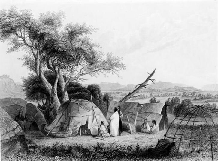
Engraving by Seth Eastman – Winnebago (Ho-Chunk) Wigwam. c. 1852

1872